Showing posts with label La Chapelle-aux-Saints. Show all posts

Tuesday, 11 March 2014

Not Again!!! Yep! The La Chapelle Not-A-Burial-Pit Not So Much Rectangular as Irregularly Ovaloid.


Despite the creeping understanding that you might begin to find this work of mine to be a tedious interruption of your intellectual life, I never tire of pointing the finger at my sub-sub-sub-field colleagues. "Colleague," and "palaeoanthropologist" are not, by the way, words that're often used in the same sentence as "Rob Gargett." Believe me. I'm not bothered by it. Nor am I particularly bothered that, in aggregate, Middle Palaeolithic archaeological research is not much more than "an Heap of Conspiracies, Rebellions, Murders, Massacres, Revolutions, Banishments; the very worst Effects that Avarice, Faction, Hypocrisy, Perfidiousness, Cruelty, Rage, Madness, Hatred, Envy, Lust, Malice, and Ambition could produce."* But, I'm not bitter; just very busy trying to school those comprising the heap, none of whom am I!

I say that I'm not bitter, because I've reached a level of enlightenment that few, I think, have imagined. Unfortunately, for me enlightenment is a dynamic process. Thus, each time I come across a mistaken inference in the literature, I am forced to transit each of the five stages of enlightenment all over again.

First, there's denial, which usually takes the form of an exclamation, for example,  "How could anybody be that stup . . . endously malinformed/mistaken/muddled!"

Thereafter comes anger. Alas, this is where my residual bitterness exerts itself. I often address myself at such times, with explosive effect. It almost always begins with, "How in the bejeezus . . ." I think you can fill in the blanks.

Next up, bargaining. Again, an exchange with myself, along the lines of, "Okay. I'll go out there and wade once more into the waste-deep swamp of fetid inferences. But it's absolutely the last time. Agreed?"

The very next level of enlightenment, in my experience, is not an entirely positive stage. It's what's known as depression, which I've learned is different from just "feeling sorry for oneself."
Depression follows whenever I feel as if I'm losing the high ground of the intellect. It's cathartic, in a way. But it's quite dangerous, because this is the tilting point, and I could quite easily take the downward emotional path and fervently hope that I'll never write another word. That's what's been going on, in large part, since about this time last year.

Enlightenment, for me, amounts to acceptance. Acceptance of my solitary fight, of an effectively Sisyphean struggle, futile in its particulars, but transforming in its utter futility. That's where I find myself on the question of Middle Palaeolithic burial. And it is in acceptance of my lot in life that I can say, "Once more into the breach, dear friends."

So. Where were we? Oh, yes. We're back at La Chapelle-aux-Saints, where, around 1908 a mostly complete skeleton of a Classic Neanderthal was found. In "Grave Shortcomings: the evidence for Neandertal burial" I thought I'd done a pretty good job of dismantling the early twentieth century fairy tale that "The Old Man" of La Chapelle-aux-Saints had been purposefully buried.
[It's not necessary to your understanding of what's coming. Nevertheless, for those few who exist unaware of my late 80's contribution to this question, I've set up a special page where you can train yourself.]

I've already thoroughly and [one would have hoped] persuasively shut down the recent claims by Rendu et al. that their exhumation of the so-called burial pit demonstrated that the skeleton was preserved because it had been purposefully buried. You can refresh your memory by having a look here, here, here, here, and here. I'd have hoped that these five blurts had exhausted the subject. But, I've found that no matter how many times you beat a dead horse, it stays dead!

The original excavations resulted in the site plan on the left, below [minus my multi-metre scale bars]. This is the only representation that exists. Any other representations that you might see are extrapolations based on the excavators' reports. The 1908 plan clearly illustrates a quasi-rectangular pit outline. [On of the main criticisms of my 1989 re-examination was that a rectangular depression was unlikely to have been created naturally. That's a false proposition, which I've covered recently, and which ought to put that fantasy to rest, once and for all.]

Below, at right you see my annotated version of the same plan based on the recent exhumations of Rendu et al. It reproduces the 1980 illustration along with the results of the latter-day excavations. As you can see, the newer outline is shifted slightly away from the preternaturally central position reported in 1908. The recent work, which we're assured exposed the original "pit," shows a slightly larger and ovoid in plan. It's a kind of ovoid trapezoid, not a rectangle.

As you'll see in a moment, even the recent results as drawn are a departure from the excavated reality, I believe so as to perpetuate the claim that the "grave" was rectangular.

Illustration at right drawn after Rendu et al. 2013.
Indeed, for much of the twentieth century, every visitor to the museum at La Chapelle-aux-Saints, or those who visit the Musee de l'Homme in Paris, have been treated to the diorama shown below (which is from the La Chapelle museum. It's decidedly rectangular, and way more rectilinear than even the 1908 plan would have you believe. So, what's going on? [As I've mentioned previously the distribution of skeletal elements in this diorama is at odds with the original plan, above left.]


What's happening is clearly illustrated in the photo below, which shows a portion of the "grave" during the recent excavation. The dashed white line describes the shape, in plan, of the "burial pit." You see where the margin closest to the photographer is not rectilinear. Far from it!

Rendu et al. 2013.

The kicker, as I see it, is the comparison of the site after the 1908 excavation, and a photo from exactly the same vantage of the site after the recent excavation. Neither appears particularly rectangular, rectilinear, or anything approaching a right-angle. The take-home message? Easy. The well-meaning archaeologists of the recent excavation have drunk the Kool-Aid, and even when faced with reality, they have chosen to undertake special pleading and auxiliary hypothesis after auxiliary hypothesis, in maintaining a) that the burial was purposeful—even though the pit might have been naturally excavated the skelly was nevertheless puposefully buried, and b) the pit's rectangular outline as recorded in 1908 was the truth, even though it's really hard to get one's eyes to turn an oval into a rectangle.
Rendu et al. 2013.


* Jonathan Swift. 1726. Travels into Several Remote Nations of the World.

Thursday, 9 January 2014

It's a Zombie Jamboree. La Chapelle-aux-Saints 1 Was Never Buried: Epilogue.

The big news of the moment is the recent claim that new evidence proves that the Old Man of La Chapelle-aux-Saints had indeed been purposefully buried by his Neanderthal buddies. As you've seen over the past week, I believe it to be more poppycock.

I've already referred to this not-really so big news as being like a zombie. You know? Dead, but undying. And it reminded me that, despite the horror movie latter-day fixation with zombies, the arts haven't always treated the idea with foreboding. The zombie has also been the target of mirth, which I witnessed in the early 1970s, during three very happy vacations in Barbados.

Barbados, at 432 square kilometres, is a tiny dot on really big maps., in the Lesser Antilles archipelago, very close to South America. Once part of the British Empire, Barbados is now a sovereign country.

If you've never been, never seen pictures, or heard of Barbados, here's a primer.

Although there were some very posh resorts, for the most part the island was, to my eye, largely unspoiled by rampant development. I'd love to go again some day, but I'm afraid it would be a disappointment. Be that as it may. It'll remain in what's left of my memory for always.

Barbados is beloved for its contribution to the world of liquor. It claims the oldest continuously operating rum distillery on the planet. Mount Gay Rum is sold world-wide, and, in fact, I bought a 750 ml bottle this afternoon at Trader Joe's.

This tiny country is also home to a contemporary pop-culture phenomenon. You'll know her as Rhianna.

Anyway. Back to the zombies. While in Barbados the first time, I stayed in a resort that had live music every night. I was there for a couple of weeks, and I heard the Sandpebbles, at the time an extremely popular Calypso band, twice. In a bit you'll be able to listen to them. But first, I must tell you about Calypso. Besides being the name of Jacques Cousteau's research ship, Calypso is the name of a multi-facetted art form. Calypso is a dance step, a genre of music, and its themes are a sort of zeitgeist that harkens back decades. I don't know how much it influenced Reggae, but I can say that performers, the beat, and [sometimes] the subjects of both genres overlap, kind of like a Venn diagram.

I don't know if I've ever had as much fun as I did on those vacations. But, who cares?


The photo at right features a Mini Moke, a soft-top vehicle that tourists can rent to explore the island. My friends and I rented a MiniMoke one afternoon. After much inhalation of the island and its liquid refreshments, we found ourselves somewhere in the middle of the island, undear the only street lamp that was visible in the moonless and starless pitch blackness, surrounded by sugarcane fields—kind of like a corn maze—with no idea which way to go. We'd been trying to find our way back to a coast—we cared not which coast—which would make it easier to find our way back to the hotel.

Bajans, how they refer to people born there, are mad about cricket, and mad about partying.

I want to commemorate those days, and the recent re-invigoration of the La Chapelle-aux-Saint burial claim, by introducing you to a song that I heard first in Barbados, and never forgot.

So, I want to leave you with a recording of the ever-popular Caribbean classic, "Zombie Jamboree," as recorded by the SandPebbles.

I hope you enjoy it as much as I did!

Thursday, 2 January 2014

Even Less Proof That Neanderthals Buried Their Dead

Yesterday, The Subversive Archaeologist, your favourite blog, received a comment on the third of three posts relating to Rendu et al.'s recent claim to have uncovered new evidence that the Old Man of La Chapelle had been purposefully buried. It came from reader Morley Eldridge. His is as disinterested a response as one could possibly hope for. Morley is steeped in the late-pre-European invasion archaeology of North America's Northwest Coast—about as far from Late Pleistocene France as you could imagine. Or maybe not. As he points out the 'soil' chemistry of shell middens and calcareous caves are very alike. His comment raises many issues that I'm pretty sure some readers will have shared. I immediately crafted an appropriate response, but was hamstrung by the character limit on Blogger/Google Comments.

So, I emailed Morley the piece, and asked if I might put up his comment and my response. He gave the green light. His comment is reproduced verbatim, as are my responses. I'm adding visual aids of what Morley's referring to. [And in the captions some after-the-fact facts that you should keep in mind.]


The Subversive Archaeologist (SA)received this comment December 31, 2013, from Morley Eldridge (ME), President of Millennia Research Limited of Victoria, BC.

ME: OK. Had to read all three posts a couple of times to get it straight.

SA: I’m sorry if I didn’t present it coherently. I do try.

ME: I do believe you are basically right Rob, and that Rendu et al were mistaken in the belief that the originally published profiles and plan had to be essentially accurate.The notch is damning if the differences in pit location and morphology are supposed to be due to 'damage'.

SA: But only basically? Just checking.

The Notch appears on the right-hand site plan. The original outline of the "grave" and position of the deceased are in red. The Rendu et al. excavation revealed that the "grave's" location was about a metre away from the original presentation. Long-time friend of the SA, Marco Langbroek, advises me that the notch was very likely created during excavation, when the skull and associated bits were removed en bloc. If true, it's proof that the excavators, Bouysonnie, Bouysonnie, and Bardon (B, B, & B), did a piss-poor job of drawing their plan. The claim that they fudged their published observations is further supported by the excellent duo of photographs that Rendu et al. published, showing the newly excavated 1908 pit compared with the recent exposure.  
There can be no doubt that B, B, & B fudged their site plan and profiles. In these two views, taken from precisely the same vantage point, the size and location of the pit appears identical. Moreover, the Notch created for removal of the skull en bloc appears to have been made almost directly below the shield of rock/travertine that can be seen in both photos of the site post excavation, and in the mid-excavation photo below. 
The pit during excavation. The excavator in red is perched precariously on a half-metre sized island of backfill, hard up against the shield rock formation. Judging by the concave profile visible beneath excavator in red, the notch had to have been almost underneath the shield of rock. It's difficult to imagine how B, B, & B could have been so far off the mark in their plan drawing. Moreover, the skull's location almost beneath the shielding rock can easily explain why the skull was excavated virtually pristine. In such locations, preservation is bound to be better than any portions of the carcass that were further away (in this case, all of the post-cranial skeleton). 
ME: Whats left is essentially an amorphous depression that contained a remarkably intact skeleton,

SA: I’ve done the math. About 50% of the skeleton is represented.

The 50% estimate is a charitable one. The true number is close to, but does not reach, 50%. If I may be allowed a bit of after-the-fact analysis, you'll notice that the backbone is well represented. I've previously argued that the Kebara Cave Neanderthal's backbone would have been preserved best of all, because lying on its back means that the vertebrae and associated soft tissue would have been first to be covered by accumulating sediments. If I'm right, and LCS1 was naturally buried, it stands to reason that his backbone would survive better than the rest of the skeleton. 
ME: and which was excavated by the standards current to the early 20th century.

SA: I have no doubt that the excavation techniques were less fine-grained than some being done today. But if Rendu et al. found very little skeletal material that B, B, & B missed. But it’s not the digging technique that fell down on the job. Neither is it the stratification observed or the stratigraphic interpretation. It was fudging the record of observations that seems to have led most of us astray for more than a century. There’s no recovering from fudged records.

ME: Has there been a concerted effort to search for the century-old field notes, or letters written to colleagues while in the field?

SA: An excellent question. But not one, I’m afraid, that I’d be enabled to undertake.

This is the only fine-grained depiction of the LCS1 Neanderthal. There are no photographs taken at the time. We have only the two views of its skull, which was removed en bloc. This representation is a museum diorama, and it clearly includes discrepancies from the original position of the remains. As I observed previously, the mandible is not in the same place as it was in the bloc that included the cranium. As for the rest, all we have to go on is the one, tiny, plan drawing of the remains that was published in 1908. And even there, one can see obvious differences between the remains as drawn by B, B, & B, and those depicted in the diorama.
ME: The position of the body looks very much like what we see in purposeful flexed pit interments in shell middens here.

SA: Which is why B, B, & B argued that LCS1 was emplaced in what looked to them like a sleeping posture. My response: death during sleep would produce the same result.

ME: The skeleton is much more intact than what we normally see, though, and I'm not bothered at all by the missing elements.

SA: We’ll have to agree to disagree on that point.

ME: Shell middens have similar chemistry to limestone and marl that preserves bone well but causes inexplicable bone loss on the micro-scale.

SA: I agree that chemistry is very important. But, in what is to all intents and purposes an impermeable basin, it’s hard even to imagine that the groundwater makeup could vary so much on a metre scale. It’s expecially difficult for me to accept that chemical variability is at fault, given the author’s description of the excellent preservation of those bits that were recovered.

ME: Plus we get all kinds of turbation and other taphonomic processes.

SA: That’s true. None were ever proposed or observed. And, as I point out, they weren’t being transported downward in the column because the depression is impermeable.

ME: I suppose some unwell Neanderthal may have crawled to the lowest point of a rockshelter, curled up into a fetal position, then expired and was somehow rapidly covered with a cultural matrix containing tools etc. naturally, and before the scavengers had time to do much gnawing.

SA: This is where you and I disagree the most. If LCS1 had expired in winter, and had frozen to death, in the north-facing bouffia it might have been June before it thawed. Scavengers are far less interested in a carcass after it has been frozen, and microbes, too, do far less microbing once a carcass has been frozen—so you don’t see the effects of bloating that you do in a carcass that wasn’t frozen.

ME: If the skeletal position was more higgelty-piggelty I'd offer up the suggestion, that I haven't heard postulated before (what say you, Rob, is the following behaviour known to palaeoanthropologists?), that perhaps a bear (U. arctos) could have buried him and covered him with dirt and debris, as grizzlies here are fond of doing with moose and caribou, and the occasionally human (some of whom have recovered enough to crawl out and away and live to tell the tale).

SA: That’s good to know. But of course, thanks to the fudged record, we have no good idea what arrangement the skeletal elements were in at the time they were excavated.

ME: One of my most scary times in the bush was realizing that the stink of rotting flesh was correlated with the pits and excavated hollows in a ridge-top aeolian (?) sand deposit and with the numerous grizzly bear tracks we'd been looking at - the bears usually hang around to guard such delicacies as they ripen. I don't see why bears wouldn't also do this in a convenient cave with soft-ish marl and midden, and it would be extremely hard to distinguish this from a purposeful burial.

SA: Thanks, Morley! Another arrow in my quiver!

ME: Obviously for one reason or another occasionally the bear doesn't return to his cache. But the regular flexed body position would suggest this wouldn't be an explanation here- unless the skeletal depiction was also 'cleaned-up' by the illustrator.

SA: Which, sadly, we’ll never know. Thanks for your thoughtful comments, Morley. I’m hoping you have a prosperous new year.


Thursday, 26 December 2013

The Neanderthals Buried Their Dead? Nu-Uh! Part Three—The Final Chapter.

[Note: this has been altered from the original. It's now nearly 5 hours since I first published this. As you read along, you'll encounter the changes, and the original text.] 
In two previous blurts at The Subversive Archaeologist, here and here, I provided some history and geological background to Rendu et al.'s paper that says they've corroborated the century-old claim that the La Chapelle-aux-Saints Neanderthal was purposefully buried.
Rendu, et al. (2013). "Evidence supporting an intentional Neandertal burial at La Chapelle-aux-Saints." PNAS (some time recently). www.pnas.org/cgi/doi/10.1073/pnas.1316780110
In all sincerity, I applaud the authors' efforts to sort out the site formation processes at La Bouffia Bonneval. [I'm being serious, now. Quit makin' those funny faces! Despite my theatrical sarcasm and occasional whiffs of disdain, I think their ambition is remarkable.] The authors are unlike so many archaeologists and palaeoanthropologists before them, who largely dismissed my 1989 observation in Current Anthropology—that natural depositional circumstances could easily account for every putative Middle Palaeolithic (MP) purposeful burial.

The not-really-very-accurate museum diorama purporting to display the LCS1 Neanderthal skeletal remains as they looked during the 1908 excavation. Despite the attempted verisimiltude, this display doesn't accord with what little we know of the remains, derived from miniature plan and profile illustrations and two photographs of the skull and associated near-cranial skeletal elements.
Thus, this paper by Rendu et al. sets itself apart from almost all their colleagues---at least the authors are taking seriously the possibility that the Old Man of La Chapelle may have been naturally buried. But they aren't the first. Sandgathe et al. crossed the finish line to examine that possibility. Their second look at the Roc de Marsal child's depositional circumstances concluded that it had likely been interred naturally. It's refreshing to be taken seriously, even if ineptly.

For me, purposeful MP burial is one---and may be the only true nexus---of importance to our understanding of Neanderthal cognitive ability. In the collective palaeoanthropological worldview, the inference of purposeful burial made imaginable all later claims for complex, modern human, Neanderthal behaviour. MP bipedal apes were undoubtedly extremely clever when compared with all of the primates that preceded them. Evidence for burial imbued Neandethals with a mind that knows itself, a mind that pondered the ineffable, that dreamed of an afterlife, and that had human emotions. I believe it's still an open question whether they controlled fire. Yet controlling fire would mean they were really clever. But what they thought about fire cannot be straightforwardly inferred from the behaviour. Notwithstanding the legitimate argument that purposeful burial may say nothing substantive about the Neanderthal's cognitive or emotional life, inferring a cosmology is much more plausible when one thinks of burial, as opposed to controlling fire.

Don't forget that Paul Pettitt has erected an entire cosmology around completely untestable, phantasmagorical, propositions as to the evolution of burial. Even I haven't been as far out there in the aether as Pettitt. At least I cleave to empirical observation. Pettitt relies on imaginary scenarios that can neither be falsified not instantiated. But that's his problem [and, I might add, that of his adherents]. Unfortunately every palaeoanthropologist that believes the Neanderthals buried their dead slavishly lap up each of Pettitt's zany hypotheses, and the task for empirically grounded archaeologists and palaeanthropologists becomes manifestly more difficult.

Nothing escapes the SA's gaze
You may already know that I have doubts about ALL claims of modern-human-like abilities in the Neanderthal repertoire. But this one issue—purposeful burial—is, I believe, paramount.

Rendu et al. thought they'd contribute by going back to La Chapelle-aux-Saints (Corrèze, France) and removing the backdirt from the  early twentieth-century excavations of Bouyssonie, Bouyssonie, and Bardon [B, B, & B]. Rather than just mimeographing the century-old findings, the authors have made new observations, and applied much-more up-to-date analytical techniques to sort out the depositional circumstances of the Old Man of La Chapelle's final resting place. Don't get too excited. Sandgathe et al. found intact deposits at the Roc de Marsal, from which they inferred the depositional circumstances of the Neanderthal child. Because they merely swept out the cave to reveal the lowest reaches of the 1908 excavations, and because they have no recourse but to assume that they've found the true extent of the putative burial pit, as you'll see, that assumption is a really dicey one. Thus, all we get from Rendu et al. is their best guess as to what happened, without any warrant either for their guesses or their unfounded conclusions.

The authors have erected an argument that falls well short of empirical certitude [if that was ever possible]. Like good scientists, they relied on empirical observation. That alone makes their paper a refreshing change from the orthodox view, which usually amounts to saying that Gargett's just wrong. I hesitate to say that Rendu et al. are wrong. I should leave that up to you. However, if they are wrong, and I'm wrong, the discipline will still be left to deal with the thorny issue of equifinality when they attempt to explain what B, B, & B report they found.

Enough ancient history! Erm . . . let's take it from where we left off. Shall we?

I think it best to let the authors do the talking. I'll butt in when necessary.
The sediments were backfill of the Bouyssonies’ excavations both inside and outside, except for small areas where in situ deposits were identified inside the cave. 
That makes it kind of a 're-exhumination.' [Forgive me. I'm a little amused that, for some inexplicable reason, Rendu et al. piece-plotted each and every artifact recovered in the 1908 backfill.] And we're walking . . .
Excavations . . . exposed a 39-cm-deep subrectangular depression cut into the substrate marl. 
Wanna know exactly how SUB-rectangular it was? It's subrectangular like a triangle is subrectangular! It's subrectangular the way a kangaroo is subrectangular. No rectilinear shape that I'm familiar with bears what appears to be a perfectly semi-circular portion of its margin. The authors manage to duck criticism with their next assertion, which they hope we'll accept as the god's honest truth.

]By the way. If you're new to the crazy and wonderful domain of the archaeologist, take note. Neither the caption for this photo, nor the text of the article, gives us any indication where in the site this is. I had to do some pretty fancy orienteering just to figure it out. The line described by the folding ruler, and the exposed profile, must be the line between the 73rd and 74th grid columns, which you can see in the plan drawing that follows this photo.

Don't you do this to your readers! Please. It's unprofessional, and it only leads to accusations of incompetence, both on the part of the authors, and the editors of the journal in which it appeared.]


The authors continue
The upper part of the pit is damaged
There's the other shoe! Damaged? That's a curious assertion if they're trying to ascertain whether or not the depression was created naturally. Specifically, what did they imagine it was going to look like if they'd never seen it before? And what, exactly, did they mean by "damaged." I think I can explain, which the authors seem disinclined to do. Have a look at the side-by-side profiles that I've carefully laid out so that the scales match.


In the recent excavation the exposed pit doesn't have the nicely vertical sides of the one you see in the 1908 profiles. It's clear to me that the authors have based their "damaged" assessment on their trust that the surface they exposed should have looked more like the one depicted in 1908. Unfortunately, there's no way to know if the 1908 excavators were fudging their observations of the pit they found. The authors say that the pit had been "damaged." That is a completely unwarranted assumption. And it's an inference without evidence. Enough nit-picking, Rob!

Returning to the author's account
the lower part [of the pit] is 140 cm long and 85 cm wide . . . . The interface of the backfill and the substratum is clear and regularly concave in this area. 
After a very brief respite from the nit-picking . . . let's try a little 'ground-truthing.' Shall we? Rendu et al. say nothing to justify their choice of measurement landmarks. As you'll see, they've got some 'splainin' to do—beginning with their evident inability to identify the 'bottom' of an archaeological feature.

In the enlarged profiles you see below, it's insanely unclear as to why the authors ignored the the true low points along the A--B cross section. Instead, they've arbitrarily defined the span they measured. This suggests forcefully that they're simply accepting the sizes in the 1908 report as gospel, and [maybe even unconsciously] allowing their expectations to govern their observations. That was, after all, the most likely reason for saying that the pit they uncovered was "damaged."

In the above illustration I've scribed lines parallel to the drawing's horizontal grid lines. The vertical line delineating the pit's bottom at the A end is fairly close to a 'bottom,' if you decide that the bottom occurs at the abrupt change in slope. The measurement point at the B end is much more problematic. It lies toward the lower end of the gentle slope, yet there's no apparent reason for choosing that point rather than another point along the line that slopes up from the bottom of the pit in the direction of B.

As for the C--D profile, the designation of 'bottom' seems equally arbitrary. Again, the bottom-most and the next-lowest points are ignored in favour of the span they've indicated. In this case I'm willing to give them the benefit of the doubt, because their idea of the pit's bottom comes close to where I'd have put it—at the break in slope [which, being reasonable, isn't where what I've labelled the 'true bottom,' rather, it's almost exactly where the authors have indicates.]

The question, "What's going on?" keeps ricocheting around in my head. The 1908 plan [a little scroll in the up direction] depicts a 'grave' that's about 100 by 200 cm. So, I'm truly baffled now. If Rendu et al. weren't measuring so that their pit had more or less the same dimensions as the one in the 1908 plan, then what were they thinking?

The next of Rendu et al.'s assertions is so far from reality as to seem almost bizarre.

[The uncovered pit's] position is identical to the location of the burial pit indicated in the Bouyssonies’ figures . . . . This is . . . supported by the relative position of the pit in relation to the relief of the roof . . . observable in the excavation pictures from the early 20th century.
Wait. What?

Their lovely plan drawing says just the opposite. Have a look [scroll up]. OK. The two depictions do overlap—the 1980 plan in red and the authors' in dark grey. But the authors' plan of the pit is by no means "identical to the location of the burial pit indicated in the Bouyssonie's figures," as the authors have stated. Believe me. I'm smelling a lot of smoke and seeing my reflection in a gazillion mirrors!
I'm not quite sure why Rendu et al. are so keen to persuade us that what they found was the very depression that B, B, & B excavated all those years ago. It's not as if there could have been another one in roughly the same part of the cave! So, why do they care? Their readers certainly would have no doubt that the authors found the "right" pit feature. Indeed, it all seems rather trivial to me. [And wouldn't have been a real howler if they hadn't been able to locate it?] I read 'em as I see 'em.


Earlier in the paper the authors recorded that in each of the neighbouring bouffiae they excavated they found periglacial effects, mostly what they refer to as cryoturbation. In La Bouffia Bonneval, they also found what they interpret as being the result of cryoturbation. Here's a picture.


K. So. The next assertion is rather bizarre, I thought.
the pit does not have the same morphology as the cryoturbation cells, ruling out a periglacial origin. 
Um. No one's ever proposed that the pit could have been the result of periglacial geomorphic changes. I guess the authors are trying to 'cover all their bases,' even those 'bases' that have no existence on this mortal plane.
No tool marks into the marl were detected. However, the pit cut partially through a cryoturbated fissure (stratigraphic unit C5) that contained Quina artifacts. 
This can't be! A fissure that's been subjected to cryoturbation? Even cutting the authors some slack for not being native English speakers, and even forgiving Erik Trinkaus for the absence of anything that comes close to editing [even though that's his marquee billing at PNAS], you might have thought that a body calling itself THE [US] National Academy of Sciences could have done a bit better. [Oh. And, BY THE WAY, how did they end up with a stratigraphic unit labelled C5 in a deposit that contained exactly one layer of backdirt?]

OK. What they meant was this: the 'cell' was actually an "injection feature" brought about by permafrost conditions some time before the Old Man was buried.
[that the "cryoturbation cell" contains Quina artifacts] demonstrates that the area of the depression was at least partially modified for the burial of LCS1, removing accumulated cultural debris and sediment. This modification would have happened after the formation of the cryoturbated fissure, thus after the Quina deposit.
Therefore, based on the excavations along the La Chapelle-aux-Saints cliff, an anthropogenic origin for the depression that contained the articulated remains of LCS1 at the bouffia Bonneval is the most parsimonious explanation.
Occam's Razor. Parsimony. You say to-mah-to and I say to-may-to. Why, then, did we not hear about this "cell" in the 1908 report? B, B, & B were keen to publish a third cross section, because they thought the little depression they found nearer to the mouth of the cave had been a part of the mortuary ritual at La Chapelle-aux-Saints. Check it out.

Funny. Odd, really.

Even if B, B, & B have represented the pit accurately in their cross sections [which I'm beginning to doubt], they must therefore have been the ones who "damaged" the pit after they'd removed LCS1. I wouldn't rule it out. Most archaeologists probe what, to them, appears to be an artifactually 'sterile' substrate. If so, what reason would they have had to probe further once they encountered the "cryoturbation cell?" None that I can think of. And, if B, B, & B did not represent the pit accurately in their cross sections, and indeed excavated a pit that was the very pit that Rendu et al. exposed, there's still no reason to think that the breached "cryoturbation cell" had been exposed during the Middle Palaeolithic burial ritual that the authors claim as fact.

If you're feeling a bit woozy from all of the twists, turns, ups, and downs contained in Rendu et al., join the club. The author's claims rest on nothing. What they're telling you is completely illogical, ON THE EVIDENCE. Sorry for shouting. I just wanted to emphasize that bit. Next we get a brief taphonomic assessment.
The results of the comparative taphonomic analysis of the human and faunal materials demonstrate that the LCS1 Neandertal corpse was rapidly interred and protected from the postdepositional modifications experienced by the faunal remains.

At the author's use of the words "the articulated remains of LCS1" the hair on the back of my neck stood up straight. It's like fingernails on glass to me. Some people think that an articulated skeleton is prima facie evidence of purposeful burial. I happen to disagree. But, even if that were true, the Old Man must have been in pretty rough shape when they buried him. Rendu et al. have presciently published the illustration you see at left. All of the unfilled portions are bits that didn't survive purposeful burial. Look at all the missing parts that B, B, & B DIDN'T find in the putative grave!

If the Neanderthals did such a bang-up job of protecting the corpse, where's the rest of the Old Man? The authors don't mention burrowing animals, which could have spirited away the missing remains. They do, however, stress how beautifully preserved the Old Man's bits were, which speaks highly of the soil chemistry's propensity for preserving collagen and apatite. So, no rodent disturbance. Good preservation. Why the missing parts?

The substrate is a very dense material. It's virtually impossible  . . . No. It is impossible for the missing bits to have percolated downward in the sedimentary column due to any number of phenomena—so often the case when burial occurs in unconsolidated sediments.

Nope. They bits they found were extremely well preserved. EXCEPT for the ones that weren't preserved at all! The authors can't invoke random diagenesis to explain the missing parts. Am I making myself clear. I'll sum it up.

Neither the reconstructed burial, nor the two 1908 plan drawings showing the skeleton give any reason for the authors to assert that LCS1's remains were IN ANY WAY articulated!

In fact, as laboratories of burial site formation processes go, La Bouffia Bonneval is a really good example of what happens when a dead animal's remains are gradually buried by natural sedimentary processes. Yet the authors want to ignore all the signs and instead make up a story without any evidence.
The existence of an artificially modified pit and the rapid burial of the body constitute convincing criteria for establishing purposeful burial during the Middle Paleolithic of Western Europe.
The authors don't know when to quit.
Whether the origin of the pit is natural or anthropogenic is not considered here as a discriminatory factor because the opportunistic use of natural depressions in funeral practices has already been demonstrated in Upper Paleolithic contexts . . .  and therefore cannot be ruled out as a possibility.
People! Know when to stop arguing. With this last statement you've effectively negated every observation and inference that you've made to this point! You. Just. Don't. Get. It.
The lack of information about the original stratigraphy and excavations makes it impossible to address the dynamic sedimentary processes involved in the filling of a pit.
I hate to be the one to say it, but, in 1989 I pointed out that B, B,  & B depicted the stratification at La Bouffia Bonneval in such a way as to nullify their claim for purposeful burial. Don't take my word for it. Remember what association is? Remember what I've said about the only un-equivocal evidence for purposeful burial? A new stratum, created at the time of the interment, which is distinct from the sediments into which the 'grave' was dug, and also distinct from those that accumulated after interment. Remember? So, we're expected to forget that B, B, & B illustrated the stratification at La Bouffia Bonneval like this?


Come on! The profile above shows the skeletal remains as part of a monolithic stratum, Stratum 1. In other words, B, B, & B couldn't distinguish between those sediments that covered the remains, and everything that was deposited afterward until Stratum 2 showed itself, at least 50 cm above the pit. [Stratum 2, by the way, is clay.]
However, three arguments support the rapid burial of the corpse: the completeness of the cranial and infracranial elements, the existence of anatomical connections, and the preservation patterns seen on the cortical surfaces of the bones.
Jesus H. Christ! That's like saying the sky is blue because the sky is blue. The point is not that relatively rapid burial occurred! The point is whether or not the rapid burial was the result of purposeful behaviour on the part of the Neanderthals that survived the Old Man. The authors have yet to address that in any meaningful way.
Microstratigraphic observation of the edges of the depression indicates that it postdates both the accumulation of Quina Mousterian deposits and their postdepositional cryoturbation and, therefore, that, originally, it cut through sediment fill, first, and then the bedrock itself.
I wasn't there, either for the original discovery, or for Act II, the re-exhumination. So, you could say I have no authority here. But if the authorities are Rendu et al., you can bet you'll be getting tarnished observations.
The anthropic origin of the excavation of this feature is the parsimonious reading of the evidence; a geogenic origin can be excluded, and there is no evidence that cave bears used the site for hibernation (and the site is too shallow for that to be possible in the first place).
So, they've pretty much ruled out everything that was never postulated as the origin of the 'pit.' And they haven't yet refuted the proposition that the pit was a solution feature. They don't need to consider other possibilities, because the authors are now the experts in the depositional history of La Bouffia Bonneval. After all, they were the ones who scooped out all the backdirt to reveal the supposedly pristine pit from which LCS1 was excavated! [Snark intentional.]

[I wish I could blame fatigue, either physical or emotional. But I can't. Marco Langbroek, friend of the SA, points out that the legend of the following plan clearly states that the notch was created by B, B, & B, probably to remove the skull en bloc, which I told you about in Part One. The good news? Rather than revealing me to be a complete boob, Marco has nailed an issue that I was unable to sort out until now. So. I'm going to strike through what I wrote previously so there's a record of my faux pas, and what I'm adding subsequent to Marco's comment will appear in bold italics. K?] I've been waiting to call your attention to a notation on the author's site plan, which gives us the 'true' location of the B, B, & B burial pit. There's a tiny anomaly recorded here that's not mentioned in the text. I'm speaking of the "Notch" that, according to the key, was excavated by B, B, & B to extract LC1's skull. The notch is, as it were, an annex to the 'pit'. W. T. F.?  W.T.F.?


This just keeps getting better. Okay. So, we have a pit feature. We have the remains of a Neanderthal. We have a claim that the pit was artificially constructed. And yet the constructors were so inept that when it came time to inter the dead relative they had to excavate an annex to the prepared grave to accommodate their beloved's head! That's Neanderthal forethought for you!

Needless to say the authors don't mention the "Notch" in the text—they'd have been nuts to do so. Perhaps it was a mistake to leave the "Notch" in the drawing and legend. If so, we're very lucky, because this cinches it for me. The authors are off their collective rocker. If the "Notch" is external to the "pit," and it was cut out by B, B, & B, the puzzle is solved. Given the disparity between the location and morphology of the 1908 pit and where it was found, and what shape it was when exposed, the authors' idea that it had been "damaged" makes perfect sense. 

Do the math.
B, B, & B drew a nice straight-sided 'grave' [see above]. Rendu et al. exposed a depression that bore little resemblance to the one illustrated in B, B, & B's publications. Rendu et al. explained the difference by claiming that the original pit had been "damaged," a conclusion that must have arisen from the belief that the 1908 diagrams were accurate. However, even though damaged—severely—Rendu et al. were able to observe a notch that B, B, & B made to remove the skull en bloc from the straight-sided pit. ]That makes no sense.] How could Rendu et al. identify the notch as such, if it extended the already damaged upper part of the pit? I'm sorry. I messed up the notch thing in the beginning. Either Rendu et al. are misidentifying a portion of the damaged upper portion of the pit, and calling it the "notch," or the "notch"they discovered gives lie to the presumed accuracy of B, B, & B's profile drawings. Either way, Rendu et al.'s argument amounts to nothing.

There was no "damage." That inference was an error that B, B, & B forced Rendu et al. to make. The 1908 illustrations are nothing like the reality that Rendu et al. observed. Thus, the pit wasn't damaged, and the Neanderthals didn't dig through the marl into the "cryoturbation cell." Rendu et al. are innocent dupes! They got suckered into fronting for B, B, & B, and substantiating their claim of purposeful burial on bogus information. My sympathies to the Rendu équipe.  

how can one possibly argue that the 'pit' itself was constructed, or altered, for the express purpose of burying a conspecific?

Un. Be. Lieve. A. Bull! At least now I can claim a little 'closure' on some of the mysteries surrounding La Bouffia Bonneval and the century-old inference of purposeful Middle Palaeolithic burial.

And, believe it or don't, I haven't addressed all of the shortcomings in Rendu et al. I do think, however, that I've exhausted the pertinent problems with Rendu et al.'s paper. I'm pretty much exhausted myself! [Apologies, again, for my slack brain in places. Call it Post-Christmas Syndrome.]

I know I should be preparing a rootin' tootin' finale.

On the other hand, by now, like me, you're probably over this whole sad chapter in the discipline of archaeology and palaeoanthropology. I say we just let it go, as it were, with a dying fall. A perfectly apt metaphor, calendrically speaking.

If music be the food of love, play on,
Give me excess of it that, surfeiting,
The appetite may sicken and so die.
That strain again, it had a dying fall.
O, it came o’er my ear like the sweet sound
That breathes upon a bank of violets,
Stealing and giving odour. Enough, no more,
’Tis not so sweet now as it was before.
[Music ceases]
O spirit of love, how quick and fresh art thou
That, notwithstanding thy capacity
Receiveth as the sea, naught enters there,
Of what validity and pitch so e’er,
But falls into abatement and low price
Even in a minute! So full of shapes is fancy
That it alone is high fantastical.
(Twelfth Night I.i.1–15)

Thanks for stopping by. See you next time.
Have a very Merry Christmas!

SA announces new posts on the Subversive Archaeologist's facebook page (mirrored on Rob Gargett's news feed), on Robert H. Gargett's Academia.edu page, Rob Gargett's twitter account, and his Google+ page. A few of you have already signed up to receive email when I post. Others have subscribed to the blog's RSS feeds. You can also become a 'member' of the blog through Google Friend Connect. Thank you for your continued patronage. You're the reason I do this.

Monday, 23 December 2013

Still No Evidence that Neanderthals Buried Their Dead. Part Deux


What does one do when one encounters a coprolite during a clustered, stratified survey of recent additions to the canon of palaeoanthropology? Does one announce to all who can hear that one is "Too cool for stool?" When one meets resistance and derision while pointing out the subtleties of palaeoanthropological inference-making with respect to fossilized dung, does one simply throw up one's hands in frustration and pray to the palaeoanthropological gods for patience? And, when no reply is forthcoming, does one exclaim with evident surprise, "No shit?" To whom can one turn? Whom does one call? Whom else? Or, is it "Who else?" Ah, Hell! I'm stickin' with "Whom else."
Who're you gonna call?
A great many archaeologists are familiar with the class of "ecofact" [or biofact] known as the human coprolite. But how many were aware that these most intimate of human artifacts were, in fact, purposefully buried? How else to explain their near-perfect preservation? Preservation of organic traces is extremely rare, unless the depositional circumstances are perfectly suited for preserving organic matter. A dry atmosphere is crucial. There must be an absolute lack of post-depositional disturbance. But how to explain such an absence? Canine carnivores are nearly ubiquitous wherever humans have lived. And everyone knows that dogs, unlike palaeanthropologists, eat faeces if there's nothing else to consume. And, even then, many, many, dogs consider it a delicacy.* But there are plenty of other bioturbators to do the job. Even the human individual that left the little treasure behind can, on occasion, step in it prior to burial—natural or otherwise—to say nothing of the unfortunate clan-mate, room-mate, or just mate can do the same quite inadvertently.

In fact, there are so many potential post-depositional disturbance processes that one can scarcely believe even the possibility of perfect preservation of people poo. In the highly dynamic environments of caves and rockshelters, human occupation commonly alternated with the activities of other animals, and the residues of both were often subjected to severe disturbance prior to being covered by natural deposition. Under such circumstances, the articulation, and nearly pristine morphology of human faeces is the major criterion for designating them intentional faecal burials. [Relax, Erella. I'm just paraphrasing. No one'll know that it's what you and Yoel and Bill said when you published your description of the Amud 7 remains and claimed that it had been purposefully buried.]

I think I'll let you . . . erm . .  . chew on that for a while, before I return to the matter of the moment—Rendu et al.'s still-warm claim to have found unequivocal evidence supporting the long-standing inference that La Chapelle-aux-Saints 1 was purposefully buried.
Okay. That's plenty of time. Onward and ever downward go we!

When last we met, I was proferring my understanding of the "state of play," as they say, with respect to the putative burial of La Chapelle-aux-Saints, up 'til the time, the other day when I found out that Rendu et al. have exhumed—not the fossil itself—the putative grave.
If you haven't already seen Part One, this might be a good time to have a look, because from here on in it's gonna get intense. And if you ain't up to speed, while you may not be left behind altogether, you'll need to run to keep up.

Despite their self-congratulatory tenor at having [they think] once—and for all time—demonstrated that the Neanderthal fossil had been purposefully buried, Rendu et al.'s effort hasn't got so-much-as-a single leg to stand on. I'm fairly confident of my conclusion relative to their "re-examination" [or better still, "re-examhumation"] of the 105-year-old claim that the Old Man of La Chapelle was purposefully buried. I can be confident because I draw on background knowledge about which the authors, evidently, haven't got a freaking clue. 

So, what do Rendu et al. want to tell us that's made their paper such a headline grabber? 

At first they ponder the geomorphology of La Bouffia Bonneval [the official name for the manger tiny hole in the ground out of which came La Chapelle-aux-Saints 1 in 1908]. It, and the others in the neighbourhood
appear as small rock shelters rather than well-developed karstic conduits. 
Instead of providing a geological or geomorphological explanation for the hole-in-the-ground, they opt for their own, subjective, description. They say what it isn't. I find it curious that they set up a dichotomous distinction between, on the one hand, 'caves' and 'rockshelters,' and on the other hand, between some unidentified erosional process and that of a karst landform created by an underground stream. Either they think that karstic caverns are only created by running water, or that at some point in the past someone proposed that these holes-in-the-ground were formed by a "karstic conduit." A point to which I return further down. Fuzzy thinking like this seems to be the best the authors can summon.

They do know at least one geological concept . . .  no, two. They say that these "rock shelters" occur at
the interface of the Upper Hettangian limestone . . . and the Lower Hettangian marl 
So, I picture a roughly horizontal contact between two kinds of rock that were laid down at the bottom of a great sea, or ocean, hundreds of million years ago. Originally the two kinds of rock would have had a contact that more or less followed a horizontal plane, because seas are big places, and for the most part their bottoms are about as close to level and linear as you can get.

Given the authors' description, I envisioned the La Chapelle bouffiae to have been formed by what usually happens when two kinds of rock are differentially eroded, whether or not the contact is horizontal. Please shift your eyes to the right for a moment. Then shift them back to what's coming.

If you're already a French Palaeolithic archaeology-ophile, you'll no doubt recognize the illustration at right. It's from Rock shelters of the Périgord: geological stratigraphy and archaeological succession. This illustration has seen a lot of daylight since its publication. Hell! I even used it in "Grave shortcomings."

This venerable graphic shows the geological parent material to be a softish layer sandwiched between two hard rock strata—rather like limestone and marl at La Chapelle, come to think of it. The softer rock ultimately loses its battle against time and the forces of nature, and you end up with a rock shelter. So, according to Laville, Rigaud, and Sackett, this is how rock shelters are done in the Périgord! Not so, apparently, in Corrèze.

So, when Rendu et al. mentioned the two layers at La Chapelle-aux-Saints, I presumed they were setting us up to expect the Périgordian kind of rockshelter evolution. Was I wrong? Or what?

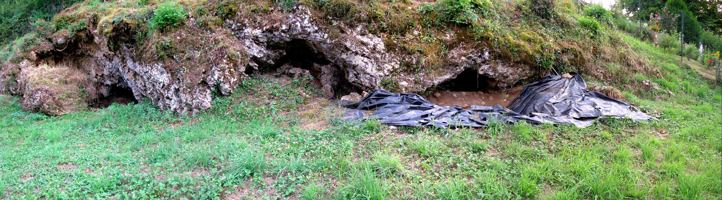
Take a look at the three bouffiae in the photo below, which are some of the Bouffia Bonneval's close neighbours. You can plainly see the openings into the bedrock that the authors want you to see as the result of differential weathering.

At La Chapelle, you don't see a more-or-less horizontal limestone brow overhanging some missing [eroded out] marly stuff. You see what I see in the photo below [thanks, once again, to Don of Don's Maps]. In fact, the only material in evidence is the limestone, and it's the rock in which the arched volume of the cave has been 'eroded.'

A series of "rockshelters" at La Chapelle-aux-Saints. Thanks to Don of Don's Maps (again!)
When I look at these Bouffias, I see an unmistakably karstic landform. The softer marl just kinda sits there, under the limestone, waiting for something to happen to to it. Either I'm blind or stupid, compared to Rendu et al., but I see each of these openings as plainly the result of a very well-known and oft-described karstic processes—bedrock breakdown. You're seeing the diminishment of the upper Hettangian limestone, which occurs at a rate determined by more variables than I'm sure you'd like to hear of. When a portion of the limestone undersurface [i.e. the cave's ceiling] can no longer defy gravity, bedrock breakdown occurs, often creating what's called a vault in the ceiling. In the case of these tiny holes at La Chapelle, it's evident that this limestone roof has held up rather nicely over the past 60 or so ka.  Nevertheless, without doubt, these are karst features. That they weren't created by flowing water is irrelevant—if not misleading. But I'm getting ahead of myself.

Rendu et al. summarize their geomorphological assessment in this way
Features related to [an] evolved karst drainage system (i.e., water circulation) are absent on the walls or the roof of the cavities . . .
I have no idea what they mean by an "evolved" anything. It's as if they think, or want us to think, that all karst was created equal. Well, it's not, and it hasn't. The authors seem to be nearly as confused about the formation of these caves as they are about archaeological site formation, which I'll get to by and by.

Returning to the paper, the authors conclude
shelter formation appears mainly connected to (i) the opening of the limestone/marl interface of the Jurassic cliff . . . ,
While true, the authors don't mention the process that brought about the important "opening" of the rock "interface." Bear with me. I'll get back to the origin of these caves a little bit further down. Forming these tiny caves was due to
(ii) the retreat of the cliff by regressive erosion,
OK. I follow.
(iii) the erosion and reworking of autochthonous weathered sediments at the lithological interface in the cliff, and (iv) the trapping of allochtonous sediments transiting along the slope.
Cool. But this description fails to address the erosional process, except to reinforce the authors' contention that this landform was not the result of a "karstic conduit," which, if it's not a red herring, is, at a minimum, a straw man.

In the map below I've highlighted the Bouffia Bonneval [I always thought was just plain ol' La Chapelle-aux-Saints].


Now, 'karst' is a many-splendoured geological process. Yet all of it is the result of a simple chemical transformation. Precipitation is enriched with carbon dioxide, creating a weak acid, which dissolves limestone and other calcareous rock.

I think it's about time for a visual. See below. I'm gonna talk as if I knew something about Karst geomorphology from here on out. So, prepare yourself.


Groundwater has only one purpose in life, that is, to find its own level. It will travel downward due to gravity. The kind of soluble rock we're talking about is never homogeneous throughout its extent. As in the diagram above, due to the Earth's constant crustal movement, limestone develops cracks that are usually depicted as brick-like features. That's a convention. But you need to know that the 'bricks' come in a nearly infinite number of sizes, and all have slightly different orientations, due to the unique geomorphological processes that have gone into their development. So, each dram of newly acidified groundwater looking for its own level will dissolve a little bit of the rock. Eventually the tiny fissures will expand, and the widening fissures will ramify, and you'll get a cave system and karst topography.

In the lowest part of the above diagram you can also clearly see what it is the authors mean when they say that Bouffia Bonneval wasn't formed as part of a "karstic conduit."  The "conduit" is the underground, horizontal watercourse that's heading toward an 'exit' into the open air. But that's just one of the myriad ways to make a cave—easily seen in the diagram. Often caves are formed without any exposure to the open. The phenomenon labelled Aven d'effondrement refers to the sinkholes that Mid-Westerners in the US are familiar with [likewise in many other parts of the world], which usually occur when a cavern develops in part through diminishment of the ceiling, as appears to be the case in the La Chapelle bouffiae. The roof is gradually eroded away until the parent rock can no longer support its own weight, and, Bingo! A swallow-hole.

You can also see in the diagram features labelled Polje and Doline. These form where surface water pools. Again, the process is gradual, but eventually you end up with a steep-sided depression that keeps getting more depressed [a little like the well-meaning archaeologist who keeps banging his head against the wall]. So, regardless of what the authors think formed the bouffiae, that it has nothing to do with flowing water is irrelevant.

One more bit to point out. Water is key to karst development. So, even though the Bouffiae are technically "dry," you can be sure that water's not far away, and that it has always been nearby, to one degree or another. Thanks to Google Street View I can show you the lay of the land. First view is from the D15 road looking toward the side of this valley in which the Bouffiae have formed.


Next view is at 180 degrees from the above view of the Bouffiae. What you see now is a narrow river flood plain with the far side of the valley evincing much the same topography as the Bouffiae side.


Just past the line of trees in the mid distance, you can see how the land rises above the flood plain, much as it does on the bouffiae side.

Finally, in the photo below, you can see trees you saw in the mid distance above, which line the geological reason for the flood plain and the valley-side terraces: Le Ruisseau La Sourdoire [loosely translated, Sourdoire Creek].


You may ask yourself, "What am I doing here?" Trying to make sense of what the brothers Bouyssonie excavated wayyyyyyyyy back in 1908.

On both sides of Sourdoire Creek there is a river-cut terrace. The river/creek you're looking at has been the area's drain for [probably] hundreds of thousands of years. You're looking at the reason for, as the authors put it, the "opening of the limestone/marl interface of the Jurassic cliff," which created the conditions for the Bouffiae to form.

Earlier in the Sourdoire's watery life it downcut through the limestone and marl, exposing the contact between the Upper Hettangian limestone and the Lower Hettangian marl that lay beneath it. Over time, blah, blah, blah. You can probably guess the rest. So, the stage is set. We know the background to discovery of the Old Man of La Chapelle, and we have the authors' considered opinion of how the bouffiae came to be,  or didn't.

The very astute among you will ask, "Why doesn't the other side of the valley have little holes poked in it?" A very good question! I'm glad you asked. On the area map above you might have noticed that the authors never learned the mapping convention that says north should always be at the top. In this case, the north arrow points toward the bottom of the map [viewed from my seat—I couldn't begin to work out what my Australian friends will make of this]. The niches developed in the south side of the valley, which at that point trends roughly east to west. So, they've always faced north. Any geologist will confirm that, in the Northern Hemisphere, if you're a naked stratigraphic sequence facing north you'll undergo very different changes to those suffered by your south-facing neighbour. I really don't want to elaborate, but I could, and you'd start to get all huffy, and then I'll resent it, and we'll get no further. So, please, be assured that you can take it from me: the Bouffiae developed where and when they did because of their relationship with the sun.

I must tell you now that, when the authors conclude that
The lack of evolved karstic morphologies and sedimentation connected to groundwater action in the bouffia Bonneval and in the adjacent La Chapelle-aux-Saints loci reject the hypothesis (7) of an endokarstic origin for the depression.
they're referring to my discussion of the site in "Grave Shortcomings." Yep. It was me! All of the authors' efforts to rule out high-pressure, high-volume, underground stream flow—those "karstic conduit" thingies—was aimed at refuting my [mere] suggestion that Bouffia Bonneval
. . . appears to have been formed at the contact between strata of different lithological composition. In cross section it is low, ellipsoid, and flat-bottomed. Thus it is most likely a bedding-plane tunnel created by high-energy underground stream flow. [emphasis added] 
Once the cave was opened to the air, which must have been shortly after cessation of the . . . [underground stream phase] . . . , archaeological deposits began accumulating.  
Transverse cross section of La Bouffia Bonneval, final resting place of La Chapelle-aux-Saints 1, the Old Man of La Chapelle, upon which I based my original hypothesis that the cave had been formed by water flowing underground. (B, B, & B 1908)
I continue
The depression itself could have occurred naturally. It is situated at a point where the slope of Stratum 5 changes from steep to level to steep again . . . It is here, where energy was lost because of the gradient change in the underground-stream phase, that heavy clasts would have tended to collect until the energy of the stream increased enough to displace them. Turbulence, friction, and increased pressure at the contact between the bedrock and the resting clasts would have eroded the underlying bedrock, leaving a depression like the "potholes" of surficial bedrock streams (see Warwick 1976:94). 
I'll admit, this seems to me now as the least likely process to have formed the cave and the 'grave.' However, in contrast with Rendu et al.'s outing in 2013, in 1989 I used the then-most current geomorphological understanding of caves and rockshelters, and combined that with the published record of the excavators. Notice, also, that in GS I said only that, to me, on the evidence, it seemed as if the small cave had once been part of a larger cave system. I used the words, "most likely." I didn't say that my hypothesis was the last word. And I didn't stop at the single hypothesis to which the authors are referring.

I suppose I can't blame Rendu et al. for overlooking what I stated as I brought to a close my 1989 critique of the La Chapelle 'burial.' What seemed to me at the time to be the "most likely" geomorphic process responsible for creating the Bouffia, was not the only possibility I wrote of. In fact, I offered several other HYPOTHESES on the potential for natural—karst—processes to have formed both the cave and the "grave."

[By the way. If you're in touch with any of the authors, could you please point out to them the following?]

In this next snippet, I conclude my effort to consider as wide a range as possible of natural forces that could explain the Bouffia's geomorphology. Here's what I had to say

Surface solution basins in a karst landscape.
Furthermore, any depression in that level stretch of the cave's sloping floor would naturally have accumulated groundwater and promoted solution. The horizontal bottom and nearly vertical sides of the "grave" at La Chapelle are in close accord with descriptions of solution basins (e.g., Sweeting 1973:83). A much fuller understanding of microtopography in caves will be needed before we can say for certain that the "grave" could not in fact be a karst feature. [emphasis added]
When I researched and wrote "Grave shortcomings," I had never been near a cave. In fact, the research I conducted for my PhD dissertation didn't require me to have been in Pod hradem cave, nor to have taken part in its excavations. The published record and the animal bones recovered in the 1950s were all I needed to form a persuasive argument regarding the potential for animals to leave spatially patterned artifacts in their 'sites.'

[All cat-calls will be reserved until after my presentation. I didn't have to be on the Titanic to figure out how it sank. So, despite what might be termed my reliance on 'book learning,' or as Pettitt repeatedly points out as a "literature-based" critique, those are argumentum ad hominem, and as such have no no bearing on whether or not my hypotheses are supported by evidence.]

So, when I finally had a chance to visit a cave, while in Mesoamerica in 1988, I observed a karst feature identical to one that I had hypothesized might explain the putative "grave" feature at La Bouffia Bonneval—what's known as a 'solution basin.' I captured an image of it in Kodachrome, and I've never before shown it to a soul. Sad to say, the quality of reproduction I present here is low. I have no slide scanner. I do have a flatbed scanner, but it has no slide copying capability. So, I placed the 35 mm slide on the flatbed, set the scanner to everything from 9600 dpi down to 600 dpi, laid two translucent storage-bin lids above the slide on the flatbed, laid my iPhone 5 on top with the LED in flashlight mode, and clicked away.

Please remember that the morphology of the feature's 'walls' aren't as clear in this presentation as they were in life [or on the slide itself]. Ready or not. Here it comes.
The black circle in the middle of this solution basin is my 35 mm camera's lens cap. So, the basin's diameter is plus or minus 1 m. The feature's shape is governed by that of the water pool that is dissolving the cave floor. The lighter colored material is medium to course sand, which is being transported across the cave floor by water washing across the surface, with the sand entrained in the current—weak though that might be. This image kicks two asses, in fact. It not only demonstrates unequivocally that such features can occur in caves in the absence of a "karstic conduit," but it also illustrates, beautifully, another claim that I've made, and which in general has been ignored. I'm speaking of the phenomenon often referred to as a 'sediment trap.' I've mentioned this phenomenon again and again in my work on MP 'burial.' Wherever there is a net-depositional sedimentary regime at work in a cave, any—ANY—depression, whether naturally or artificially created—by humans, fossil bipedal apes, or animals—will INEVITABLY accumulate sediments faster than would be the case on the surface that surrounds it.

In the above photo, from a point about level with the lens cap [i.e., the upper part of the image], you can clearly see that the surface—into which the basin is being incised—is bereft of the lighter-coloured sand that's being deposited in the solution pit and which mantles the surface from the lens cap to the camera's position.

Furthermore, as with the little, surficial feature shown above, the walls of the Mesoamerican solution basin are virtually vertical [try saying that five times really fast!], and about 30 to 40 mm from the pit's bottom to the surrounding surface. It's clearly a geologically 'young' feature.

Nearly 25 years after publishing "Grave shortcomings," I've settled on what I think is a slam-dunk explanation for the 'grave' at La Chapelle. A plain ol' ordinary solution feature is the most logical, and, for me, compelling explanation for the natural presence of a vertical-walled pit inside a cave.

If we can presume that the excavators' cross section is an accurate depiction, have a look at the profile below, and remember that in "Grave shortcomings" I called attention to the break in the slope of the parent material, the marl, just where the fossil remains were found. If accurate, you can see that to the right of the pit the upper surface of Stratum 5 is higher than that of 5's upper surface to the left of the pit. Regardless of the source—whether rain blown in, or driplets from the ceiling of the cave—if there had been no pit to begin with, it's a sure bet that water would have pooled precisely where the pit occurs.

So, let's add it up: softish marl + break in slope + pooling water + dissolution = natural formation of a vertical-sided solution feature.

Longitudinal cross section of La Bouffia Bonneval. (B, B, & B 1908)
Copyright owned by GoCave dot com. Thanks for the loan!
In that vein, and to forestall the inevitable, "But the real solution basin you showed us was circular. And the Bouyssonie's and Bardon clearly described a rectangular depression! So, nyah!" After about five minutes on google images I found a solution feature that's hard at work becoming itself on a nameless, faceless cave floor somewhere on the planet. It's not circular. As the image at left illustrates,  the lay of the land will determine the shape a solution basin.

I'm getting awfully weary. So, I think I'll call it a day. Part Three of my response to Rendu et al. will arrive sometime early in the work week. That'll be when the rubber meets the road, palaeoanthropologically speaking.

But before I go, I'll leave you with one final observation. It has to do with the origin of the 'grave,' about which I've been expounding. As far as I know, the process that created the bouffiae has little bearing on the issue of purposeful burial. Even the origin of the pit/'grave' is, in practical terms, irrelevant to the question of whether or not the Old Man was purposefully buried. As I made plain in "Grave shortcomings" and elsewhere in my writing on the subject, THE ONLY PRIMA FACIE EVIDENCE for a purposeful burial is the presence of a NEW STRATUM, created at the time of the burial, THAT IS DISTINCT from that into which, or on which, the remains came to rest, and is equally DISTINCT from that which accumulated above it.

See you next time.
* How do we know that? We know from ethologists and zoologists given to anthropomorphizing domestic and even wild animals. Bossy the cow, Pussy the cat, and Rover the dog are, as everyone knows, just like people in many of their behaviours.


SA announces new posts on the Subversive Archaeologist's facebook page (mirrored on Rob Gargett's news feed), on Robert H. Gargett's Academia.edu page, Rob Gargett's twitter account, and his Google+ page. A few of you have already signed up to receive email when I post. Others have subscribed to the blog's RSS feeds. You can also become a 'member' of the blog through Google Friend Connect. Thank you for your continued patronage. You're the reason I do this.