What does one do when one encounters a coprolite during a clustered, stratified survey of recent additions to the canon of palaeoanthropology? Does one announce to all who can hear that one is "Too cool for stool?" When one meets resistance and derision while pointing out the subtleties of palaeoanthropological inference-making with respect to fossilized dung, does one simply throw up one's hands in frustration and pray to the palaeoanthropological gods for patience? And, when no reply is forthcoming, does one exclaim with evident surprise, "No shit?" To whom can one turn? Whom does one call? Whom else? Or, is it "Who else?" Ah, Hell! I'm stickin' with "Whom else."
 |
| Who're you gonna call? |
In fact, there are so many potential post-depositional disturbance processes that one can scarcely believe even the possibility of perfect preservation of people poo. In the highly dynamic environments of caves and rockshelters, human occupation commonly alternated with the activities of other animals, and the residues of both were often subjected to severe disturbance prior to being covered by natural deposition. Under such circumstances, the articulation, and nearly pristine morphology of human faeces is the major criterion for designating them intentional faecal burials. [Relax, Erella. I'm just paraphrasing. No one'll know that it's what you and Yoel and Bill said when you published your description of the Amud 7 remains and claimed that it had been purposefully buried.]
I think I'll let you . . . erm . . . chew on that for a while, before I return to the matter of the moment—Rendu et al.'s still-warm claim to have found unequivocal evidence supporting the long-standing inference that La Chapelle-aux-Saints 1 was purposefully buried.
Okay. That's plenty of time. Onward and ever downward go we!
When last we met, I was proferring my understanding of the "state of play," as they say, with respect to the putative burial of La Chapelle-aux-Saints, up 'til the time, the other day when I found out that Rendu et al. have exhumed—not the fossil itself—the putative grave.
Despite their self-congratulatory tenor at having [they think] once—and for all time—demonstrated that the Neanderthal fossil had been purposefully buried, Rendu et al.'s effort hasn't got so-much-as-a single leg to stand on. I'm fairly confident of my conclusion relative to their "re-examination" [or better still, "re-examhumation"] of the 105-year-old claim that the Old Man of La Chapelle was purposefully buried. I can be confident because I draw on background knowledge about which the authors, evidently, haven't got a freaking clue.
So, what do Rendu et al. want to tell us that's made their paper such a headline grabber?
At first they ponder the geomorphology of La Bouffia Bonneval [the official name for the
appear as small rock shelters rather than well-developed karstic conduits.Instead of providing a geological or geomorphological explanation for the hole-in-the-ground, they opt for their own, subjective, description. They say what it isn't. I find it curious that they set up a dichotomous distinction between, on the one hand, 'caves' and 'rockshelters,' and on the other hand, between some unidentified erosional process and that of a karst landform created by an underground stream. Either they think that karstic caverns are only created by running water, or that at some point in the past someone proposed that these holes-in-the-ground were formed by a "karstic conduit." A point to which I return further down. Fuzzy thinking like this seems to be the best the authors can summon.
They do know at least one geological concept . . . no, two. They say that these "rock shelters" occur at
the interface of the Upper Hettangian limestone . . . and the Lower Hettangian marl
So, I picture a roughly horizontal contact between two kinds of rock that were laid down at the bottom of a great sea, or ocean, hundreds of million years ago. Originally the two kinds of rock would have had a contact that more or less followed a horizontal plane, because seas are big places, and for the most part their bottoms are about as close to level and linear as you can get.

Given the authors' description, I envisioned the La Chapelle bouffiae to have been formed by what usually happens when two kinds of rock are differentially eroded, whether or not the contact is horizontal. Please shift your eyes to the right for a moment. Then shift them back to what's coming.
If you're already a French Palaeolithic archaeology-ophile, you'll no doubt recognize the illustration at right. It's from Rock shelters of the Périgord: geological stratigraphy and archaeological succession. This illustration has seen a lot of daylight since its publication. Hell! I even used it in "Grave shortcomings."
If you're already a French Palaeolithic archaeology-ophile, you'll no doubt recognize the illustration at right. It's from Rock shelters of the Périgord: geological stratigraphy and archaeological succession. This illustration has seen a lot of daylight since its publication. Hell! I even used it in "Grave shortcomings."
This venerable graphic shows the geological parent material to be a softish layer sandwiched between two hard rock strata—rather like limestone and marl at La Chapelle, come to think of it. The softer rock ultimately loses its battle against time and the forces of nature, and you end up with a rock shelter. So, according to Laville, Rigaud, and Sackett, this is how rock shelters are done in the Périgord! Not so, apparently, in Corrèze.
So, when Rendu et al. mentioned the two layers at La Chapelle-aux-Saints, I presumed they were setting us up to expect the Périgordian kind of rockshelter evolution. Was I wrong? Or what?
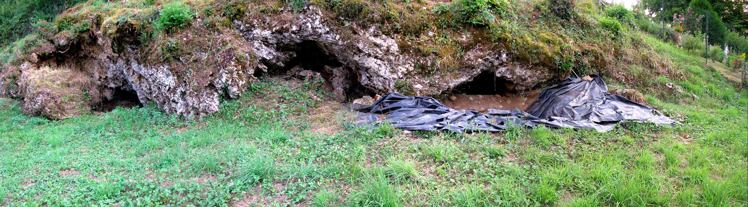
Take a look at the three bouffiae in the photo below, which are some of the Bouffia Bonneval's close neighbours. You can plainly see the openings into the bedrock that the authors want you to see as the result of differential weathering.
At La Chapelle, you don't see a more-or-less horizontal limestone brow overhanging some missing [eroded out] marly stuff. You see what I see in the photo below [thanks, once again, to Don of Don's Maps]. In fact, the only material in evidence is the limestone, and it's the rock in which the arched volume of the cave has been 'eroded.'
At La Chapelle, you don't see a more-or-less horizontal limestone brow overhanging some missing [eroded out] marly stuff. You see what I see in the photo below [thanks, once again, to Don of Don's Maps]. In fact, the only material in evidence is the limestone, and it's the rock in which the arched volume of the cave has been 'eroded.'
 |
| A series of "rockshelters" at La Chapelle-aux-Saints. Thanks to Don of Don's Maps (again!) |
When I look at these Bouffias, I see an unmistakably karstic landform. The softer marl just kinda sits there, under the limestone, waiting for something to happen to to it. Either I'm blind or stupid, compared to Rendu et al., but I see each of these openings as plainly the result of a very well-known and oft-described karstic processes—bedrock breakdown. You're seeing the diminishment of the upper Hettangian limestone, which occurs at a rate determined by more variables than I'm sure you'd like to hear of. When a portion of the limestone undersurface [i.e. the cave's ceiling] can no longer defy gravity, bedrock breakdown occurs, often creating what's called a vault in the ceiling. In the case of these tiny holes at La Chapelle, it's evident that this limestone roof has held up rather nicely over the past 60 or so ka. Nevertheless, without doubt, these are karst features. That they weren't created by flowing water is irrelevant—if not misleading. But I'm getting ahead of myself.
Rendu et al. summarize their geomorphological assessment in this way
Returning to the paper, the authors conclude
In the map below I've highlighted the Bouffia Bonneval [I always thought was just plain ol' La Chapelle-aux-Saints].

Now, 'karst' is a many-splendoured geological process. Yet all of it is the result of a simple chemical transformation. Precipitation is enriched with carbon dioxide, creating a weak acid, which dissolves limestone and other calcareous rock.
I think it's about time for a visual. See below. I'm gonna talk as if I knew something about Karst geomorphology from here on out. So, prepare yourself.

Groundwater has only one purpose in life, that is, to find its own level. It will travel downward due to gravity. The kind of soluble rock we're talking about is never homogeneous throughout its extent. As in the diagram above, due to the Earth's constant crustal movement, limestone develops cracks that are usually depicted as brick-like features. That's a convention. But you need to know that the 'bricks' come in a nearly infinite number of sizes, and all have slightly different orientations, due to the unique geomorphological processes that have gone into their development. So, each dram of newly acidified groundwater looking for its own level will dissolve a little bit of the rock. Eventually the tiny fissures will expand, and the widening fissures will ramify, and you'll get a cave system and karst topography.
In the lowest part of the above diagram you can also clearly see what it is the authors mean when they say that Bouffia Bonneval wasn't formed as part of a "karstic conduit." The "conduit" is the underground, horizontal watercourse that's heading toward an 'exit' into the open air. But that's just one of the myriad ways to make a cave—easily seen in the diagram. Often caves are formed without any exposure to the open. The phenomenon labelled Aven d'effondrement refers to the sinkholes that Mid-Westerners in the US are familiar with [likewise in many other parts of the world], which usually occur when a cavern develops in part through diminishment of the ceiling, as appears to be the case in the La Chapelle bouffiae. The roof is gradually eroded away until the parent rock can no longer support its own weight, and, Bingo! A swallow-hole.
You can also see in the diagram features labelled Polje and Doline. These form where surface water pools. Again, the process is gradual, but eventually you end up with a steep-sided depression that keeps getting more depressed [a little like the well-meaning archaeologist who keeps banging his head against the wall]. So, regardless of what the authors think formed the bouffiae, that it has nothing to do with flowing water is irrelevant.
One more bit to point out. Water is key to karst development. So, even though the Bouffiae are technically "dry," you can be sure that water's not far away, and that it has always been nearby, to one degree or another. Thanks to Google Street View I can show you the lay of the land. First view is from the D15 road looking toward the side of this valley in which the Bouffiae have formed.


Just past the line of trees in the mid distance, you can see how the land rises above the flood plain, much as it does on the bouffiae side.
Finally, in the photo below, you can see trees you saw in the mid distance above, which line the geological reason for the flood plain and the valley-side terraces: Le Ruisseau La Sourdoire [loosely translated, Sourdoire Creek].

You may ask yourself, "What am I doing here?" Trying to make sense of what the brothers Bouyssonie excavated wayyyyyyyyy back in 1908.
On both sides of Sourdoire Creek there is a river-cut terrace. The river/creek you're looking at has been the area's drain for [probably] hundreds of thousands of years. You're looking at the reason for, as the authors put it, the "opening of the limestone/marl interface of the Jurassic cliff," which created the conditions for the Bouffiae to form.
Earlier in the Sourdoire's watery life it downcut through the limestone and marl, exposing the contact between the Upper Hettangian limestone and the Lower Hettangian marl that lay beneath it. Over time, blah, blah, blah. You can probably guess the rest. So, the stage is set. We know the background to discovery of the Old Man of La Chapelle, and we have the authors' considered opinion of how the bouffiae came to be, or didn't.
The very astute among you will ask, "Why doesn't the other side of the valley have little holes poked in it?" A very good question! I'm glad you asked. On the area map above you might have noticed that the authors never learned the mapping convention that says north should always be at the top. In this case, the north arrow points toward the bottom of the map [viewed from my seat—I couldn't begin to work out what my Australian friends will make of this]. The niches developed in the south side of the valley, which at that point trends roughly east to west. So, they've always faced north. Any geologist will confirm that, in the Northern Hemisphere, if you're a naked stratigraphic sequence facing north you'll undergo very different changes to those suffered by your south-facing neighbour. I really don't want to elaborate, but I could, and you'd start to get all huffy, and then I'll resent it, and we'll get no further. So, please, be assured that you can take it from me: the Bouffiae developed where and when they did because of their relationship with the sun.
I must tell you now that, when the authors conclude that
I continue
I suppose I can't blame Rendu et al. for overlooking what I stated as I brought to a close my 1989 critique of the La Chapelle 'burial.' What seemed to me at the time to be the "most likely" geomorphic process responsible for creating the Bouffia, was not the only possibility I wrote of. In fact, I offered several other HYPOTHESES on the potential for natural—karst—processes to have formed both the cave and the "grave."
[By the way. If you're in touch with any of the authors, could you please point out to them the following?]
In this next snippet, I conclude my effort to consider as wide a range as possible of natural forces that could explain the Bouffia's geomorphology. Here's what I had to say
When I researched and wrote "Grave shortcomings," I had never been near a cave. In fact, the research I conducted for my PhD dissertation didn't require me to have been in Pod hradem cave, nor to have taken part in its excavations. The published record and the animal bones recovered in the 1950s were all I needed to form a persuasive argument regarding the potential for animals to leave spatially patterned artifacts in their 'sites.'
[All cat-calls will be reserved until after my presentation. I didn't have to be on the Titanic to figure out how it sank. So, despite what might be termed my reliance on 'book learning,' or as Pettitt repeatedly points out as a "literature-based" critique, those are argumentum ad hominem, and as such have no no bearing on whether or not my hypotheses are supported by evidence.]
So, when I finally had a chance to visit a cave, while in Mesoamerica in 1988, I observed a karst feature identical to one that I had hypothesized might explain the putative "grave" feature at La Bouffia Bonneval—what's known as a 'solution basin.' I captured an image of it in Kodachrome, and I've never before shown it to a soul. Sad to say, the quality of reproduction I present here is low. I have no slide scanner. I do have a flatbed scanner, but it has no slide copying capability. So, I placed the 35 mm slide on the flatbed, set the scanner to everything from 9600 dpi down to 600 dpi, laid two translucent storage-bin lids above the slide on the flatbed, laid my iPhone 5 on top with the LED in flashlight mode, and clicked away.
Please remember that the morphology of the feature's 'walls' aren't as clear in this presentation as they were in life [or on the slide itself]. Ready or not. Here it comes.
 The black circle in the middle of this solution basin is my 35 mm camera's lens cap. So, the basin's diameter is plus or minus 1 m. The feature's shape is governed by that of the water pool that is dissolving the cave floor. The lighter colored material is medium to course sand, which is being transported across the cave floor by water washing across the surface, with the sand entrained in the current—weak though that might be. This image kicks two asses, in fact. It not only demonstrates unequivocally that such features can occur in caves in the absence of a "karstic conduit," but it also illustrates, beautifully, another claim that I've made, and which in general has been ignored. I'm speaking of the phenomenon often referred to as a 'sediment trap.' I've mentioned this phenomenon again and again in my work on MP 'burial.' Wherever there is a net-depositional sedimentary regime at work in a cave, any—ANY—depression, whether naturally or artificially created—by humans, fossil bipedal apes, or animals—will INEVITABLY accumulate sediments faster than would be the case on the surface that surrounds it.
In the above photo, from a point about level with the lens cap [i.e., the upper part of the image], you can clearly see that the surface—into which the basin is being incised—is bereft of the lighter-coloured sand that's being deposited in the solution pit and which mantles the surface from the lens cap to the camera's position.
Furthermore, as with the little, surficial feature shown above, the walls of the Mesoamerican solution basin are virtually vertical [try saying that five times really fast!], and about 30 to 40 mm from the pit's bottom to the surrounding surface. It's clearly a geologically 'young' feature.
Nearly 25 years after publishing "Grave shortcomings," I've settled on what I think is a slam-dunk explanation for the 'grave' at La Chapelle. A plain ol' ordinary solution feature is the most logical, and, for me, compelling explanation for the natural presence of a vertical-walled pit inside a cave.
If we can presume that the excavators' cross section is an accurate depiction, have a look at the profile below, and remember that in "Grave shortcomings" I called attention to the break in the slope of the parent material, the marl, just where the fossil remains were found. If accurate, you can see that to the right of the pit the upper surface of Stratum 5 is higher than that of 5's upper surface to the left of the pit. Regardless of the source—whether rain blown in, or driplets from the ceiling of the cave—if there had been no pit to begin with, it's a sure bet that water would have pooled precisely where the pit occurs.
So, let's add it up: softish marl + break in slope + pooling water + dissolution = natural formation of a vertical-sided solution feature.
In that vein, and to forestall the inevitable, "But the real solution basin you showed us was circular. And the Bouyssonie's and Bardon clearly described a rectangular depression! So, nyah!" After about five minutes on google images I found a solution feature that's hard at work becoming itself on a nameless, faceless cave floor somewhere on the planet. It's not circular. As the image at left illustrates, the lay of the land will determine the shape a solution basin.
I'm getting awfully weary. So, I think I'll call it a day. Part Three of my response to Rendu et al. will arrive sometime early in the work week. That'll be when the rubber meets the road, palaeoanthropologically speaking.
But before I go, I'll leave you with one final observation. It has to do with the origin of the 'grave,' about which I've been expounding. As far as I know, the process that created the bouffiae has little bearing on the issue of purposeful burial. Even the origin of the pit/'grave' is, in practical terms, irrelevant to the question of whether or not the Old Man was purposefully buried. As I made plain in "Grave shortcomings" and elsewhere in my writing on the subject, THE ONLY PRIMA FACIE EVIDENCE for a purposeful burial is the presence of a NEW STRATUM, created at the time of the burial, THAT IS DISTINCT from that into which, or on which, the remains came to rest, and is equally DISTINCT from that which accumulated above it.
See you next time.
 SA announces new posts on the Subversive Archaeologist's facebook page (mirrored on Rob Gargett's news feed), on Robert H. Gargett's Academia.edu page, Rob Gargett's twitter account, and his Google+ page. A few of you have already signed up to receive email when I post. Others have subscribed to the blog's RSS feeds. You can also become a 'member' of the blog through Google Friend Connect. Thank you for your continued patronage. You're the reason I do this.
Features related to [an] evolved karst drainage system (i.e., water circulation) are absent on the walls or the roof of the cavities . . .I have no idea what they mean by an "evolved" anything. It's as if they think, or want us to think, that all karst was created equal. Well, it's not, and it hasn't. The authors seem to be nearly as confused about the formation of these caves as they are about archaeological site formation, which I'll get to by and by.
Returning to the paper, the authors conclude
shelter formation appears mainly connected to (i) the opening of the limestone/marl interface of the Jurassic cliff . . . ,While true, the authors don't mention the process that brought about the important "opening" of the rock "interface." Bear with me. I'll get back to the origin of these caves a little bit further down. Forming these tiny caves was due to
(ii) the retreat of the cliff by regressive erosion,OK. I follow.
(iii) the erosion and reworking of autochthonous weathered sediments at the lithological interface in the cliff, and (iv) the trapping of allochtonous sediments transiting along the slope.Cool. But this description fails to address the erosional process, except to reinforce the authors' contention that this landform was not the result of a "karstic conduit," which, if it's not a red herring, is, at a minimum, a straw man.
In the map below I've highlighted the Bouffia Bonneval [I always thought was just plain ol' La Chapelle-aux-Saints].
I think it's about time for a visual. See below. I'm gonna talk as if I knew something about Karst geomorphology from here on out. So, prepare yourself.
Groundwater has only one purpose in life, that is, to find its own level. It will travel downward due to gravity. The kind of soluble rock we're talking about is never homogeneous throughout its extent. As in the diagram above, due to the Earth's constant crustal movement, limestone develops cracks that are usually depicted as brick-like features. That's a convention. But you need to know that the 'bricks' come in a nearly infinite number of sizes, and all have slightly different orientations, due to the unique geomorphological processes that have gone into their development. So, each dram of newly acidified groundwater looking for its own level will dissolve a little bit of the rock. Eventually the tiny fissures will expand, and the widening fissures will ramify, and you'll get a cave system and karst topography.
In the lowest part of the above diagram you can also clearly see what it is the authors mean when they say that Bouffia Bonneval wasn't formed as part of a "karstic conduit." The "conduit" is the underground, horizontal watercourse that's heading toward an 'exit' into the open air. But that's just one of the myriad ways to make a cave—easily seen in the diagram. Often caves are formed without any exposure to the open. The phenomenon labelled Aven d'effondrement refers to the sinkholes that Mid-Westerners in the US are familiar with [likewise in many other parts of the world], which usually occur when a cavern develops in part through diminishment of the ceiling, as appears to be the case in the La Chapelle bouffiae. The roof is gradually eroded away until the parent rock can no longer support its own weight, and, Bingo! A swallow-hole.
You can also see in the diagram features labelled Polje and Doline. These form where surface water pools. Again, the process is gradual, but eventually you end up with a steep-sided depression that keeps getting more depressed [a little like the well-meaning archaeologist who keeps banging his head against the wall]. So, regardless of what the authors think formed the bouffiae, that it has nothing to do with flowing water is irrelevant.
One more bit to point out. Water is key to karst development. So, even though the Bouffiae are technically "dry," you can be sure that water's not far away, and that it has always been nearby, to one degree or another. Thanks to Google Street View I can show you the lay of the land. First view is from the D15 road looking toward the side of this valley in which the Bouffiae have formed.

Next view is at 180 degrees from the above view of the Bouffiae. What you see now is a narrow river flood plain with the far side of the valley evincing much the same topography as the Bouffiae side.

Just past the line of trees in the mid distance, you can see how the land rises above the flood plain, much as it does on the bouffiae side.
Finally, in the photo below, you can see trees you saw in the mid distance above, which line the geological reason for the flood plain and the valley-side terraces: Le Ruisseau La Sourdoire [loosely translated, Sourdoire Creek].

You may ask yourself, "What am I doing here?" Trying to make sense of what the brothers Bouyssonie excavated wayyyyyyyyy back in 1908.
On both sides of Sourdoire Creek there is a river-cut terrace. The river/creek you're looking at has been the area's drain for [probably] hundreds of thousands of years. You're looking at the reason for, as the authors put it, the "opening of the limestone/marl interface of the Jurassic cliff," which created the conditions for the Bouffiae to form.
Earlier in the Sourdoire's watery life it downcut through the limestone and marl, exposing the contact between the Upper Hettangian limestone and the Lower Hettangian marl that lay beneath it. Over time, blah, blah, blah. You can probably guess the rest. So, the stage is set. We know the background to discovery of the Old Man of La Chapelle, and we have the authors' considered opinion of how the bouffiae came to be, or didn't.
The very astute among you will ask, "Why doesn't the other side of the valley have little holes poked in it?" A very good question! I'm glad you asked. On the area map above you might have noticed that the authors never learned the mapping convention that says north should always be at the top. In this case, the north arrow points toward the bottom of the map [viewed from my seat—I couldn't begin to work out what my Australian friends will make of this]. The niches developed in the south side of the valley, which at that point trends roughly east to west. So, they've always faced north. Any geologist will confirm that, in the Northern Hemisphere, if you're a naked stratigraphic sequence facing north you'll undergo very different changes to those suffered by your south-facing neighbour. I really don't want to elaborate, but I could, and you'd start to get all huffy, and then I'll resent it, and we'll get no further. So, please, be assured that you can take it from me: the Bouffiae developed where and when they did because of their relationship with the sun.
I must tell you now that, when the authors conclude that
The lack of evolved karstic morphologies and sedimentation connected to groundwater action in the bouffia Bonneval and in the adjacent La Chapelle-aux-Saints loci reject the hypothesis (7) of an endokarstic origin for the depression.they're referring to my discussion of the site in "Grave Shortcomings." Yep. It was me! All of the authors' efforts to rule out high-pressure, high-volume, underground stream flow—those "karstic conduit" thingies—was aimed at refuting my [mere] suggestion that Bouffia Bonneval
. . . appears to have been formed at the contact between strata of different lithological composition. In cross section it is low, ellipsoid, and flat-bottomed. Thus it is most likely a bedding-plane tunnel created by high-energy underground stream flow. [emphasis added]
Once the cave was opened to the air, which must have been shortly after cessation of the . . . [underground stream phase] . . . , archaeological deposits began accumulating.
 |
Transverse cross section of La Bouffia Bonneval, final resting place of La Chapelle-aux-Saints 1, the Old Man of La Chapelle, upon which I based my original hypothesis that the cave had been formed by water flowing underground. (B, B, & B 1908)
|
The depression itself could have occurred naturally. It is situated at a point where the slope of Stratum 5 changes from steep to level to steep again . . . It is here, where energy was lost because of the gradient change in the underground-stream phase, that heavy clasts would have tended to collect until the energy of the stream increased enough to displace them. Turbulence, friction, and increased pressure at the contact between the bedrock and the resting clasts would have eroded the underlying bedrock, leaving a depression like the "potholes" of surficial bedrock streams (see Warwick 1976:94).I'll admit, this seems to me now as the least likely process to have formed the cave and the 'grave.' However, in contrast with Rendu et al.'s outing in 2013, in 1989 I used the then-most current geomorphological understanding of caves and rockshelters, and combined that with the published record of the excavators. Notice, also, that in GS I said only that, to me, on the evidence, it seemed as if the small cave had once been part of a larger cave system. I used the words, "most likely." I didn't say that my hypothesis was the last word. And I didn't stop at the single hypothesis to which the authors are referring.
[By the way. If you're in touch with any of the authors, could you please point out to them the following?]
In this next snippet, I conclude my effort to consider as wide a range as possible of natural forces that could explain the Bouffia's geomorphology. Here's what I had to say
 |
| Surface solution basins in a karst landscape. |
Furthermore, any depression in that level stretch of the cave's sloping floor would naturally have accumulated groundwater and promoted solution. The horizontal bottom and nearly vertical sides of the "grave" at La Chapelle are in close accord with descriptions of solution basins (e.g., Sweeting 1973:83). A much fuller understanding of microtopography in caves will be needed before we can say for certain that the "grave" could not in fact be a karst feature. [emphasis added]
[All cat-calls will be reserved until after my presentation. I didn't have to be on the Titanic to figure out how it sank. So, despite what might be termed my reliance on 'book learning,' or as Pettitt repeatedly points out as a "literature-based" critique, those are argumentum ad hominem, and as such have no no bearing on whether or not my hypotheses are supported by evidence.]
So, when I finally had a chance to visit a cave, while in Mesoamerica in 1988, I observed a karst feature identical to one that I had hypothesized might explain the putative "grave" feature at La Bouffia Bonneval—what's known as a 'solution basin.' I captured an image of it in Kodachrome, and I've never before shown it to a soul. Sad to say, the quality of reproduction I present here is low. I have no slide scanner. I do have a flatbed scanner, but it has no slide copying capability. So, I placed the 35 mm slide on the flatbed, set the scanner to everything from 9600 dpi down to 600 dpi, laid two translucent storage-bin lids above the slide on the flatbed, laid my iPhone 5 on top with the LED in flashlight mode, and clicked away.
Please remember that the morphology of the feature's 'walls' aren't as clear in this presentation as they were in life [or on the slide itself]. Ready or not. Here it comes.
In the above photo, from a point about level with the lens cap [i.e., the upper part of the image], you can clearly see that the surface—into which the basin is being incised—is bereft of the lighter-coloured sand that's being deposited in the solution pit and which mantles the surface from the lens cap to the camera's position.
Furthermore, as with the little, surficial feature shown above, the walls of the Mesoamerican solution basin are virtually vertical [try saying that five times really fast!], and about 30 to 40 mm from the pit's bottom to the surrounding surface. It's clearly a geologically 'young' feature.
Nearly 25 years after publishing "Grave shortcomings," I've settled on what I think is a slam-dunk explanation for the 'grave' at La Chapelle. A plain ol' ordinary solution feature is the most logical, and, for me, compelling explanation for the natural presence of a vertical-walled pit inside a cave.
If we can presume that the excavators' cross section is an accurate depiction, have a look at the profile below, and remember that in "Grave shortcomings" I called attention to the break in the slope of the parent material, the marl, just where the fossil remains were found. If accurate, you can see that to the right of the pit the upper surface of Stratum 5 is higher than that of 5's upper surface to the left of the pit. Regardless of the source—whether rain blown in, or driplets from the ceiling of the cave—if there had been no pit to begin with, it's a sure bet that water would have pooled precisely where the pit occurs.
So, let's add it up: softish marl + break in slope + pooling water + dissolution = natural formation of a vertical-sided solution feature.
 |
| Longitudinal cross section of La Bouffia Bonneval. (B, B, & B 1908) |
 |
| Copyright owned by GoCave dot com. Thanks for the loan! |
I'm getting awfully weary. So, I think I'll call it a day. Part Three of my response to Rendu et al. will arrive sometime early in the work week. That'll be when the rubber meets the road, palaeoanthropologically speaking.
But before I go, I'll leave you with one final observation. It has to do with the origin of the 'grave,' about which I've been expounding. As far as I know, the process that created the bouffiae has little bearing on the issue of purposeful burial. Even the origin of the pit/'grave' is, in practical terms, irrelevant to the question of whether or not the Old Man was purposefully buried. As I made plain in "Grave shortcomings" and elsewhere in my writing on the subject, THE ONLY PRIMA FACIE EVIDENCE for a purposeful burial is the presence of a NEW STRATUM, created at the time of the burial, THAT IS DISTINCT from that into which, or on which, the remains came to rest, and is equally DISTINCT from that which accumulated above it.
See you next time.
* How do we know that? We know from ethologists and zoologists given to anthropomorphizing domestic and even wild animals. Bossy the cow, Pussy the cat, and Rover the dog are, as everyone knows, just like people in many of their behaviours.
No comments:
Post a Comment
Thanks for visiting!
Note: only a member of this blog may post a comment.